![](/images/other/stat-length.png)
![Randonnée Marche La Petite-Pierre - 2021-03-06 Marche La Petite Pierre - Photo](https://media.geolcdn.com/t/1900/400/cf5f41c9-199e-470a-a027-f5d656cef4b3.jpg&format=pjpeg&maxdim=2)
2021-03-06 Marche La Petite Pierre
holtzv
Utilisateur GUIDE
![Longueur](/images/other/stat-length.png)
Longueur
15,5 km
![Altitude max](https://static1.geolcdn.com/siteimages/upload/files/1508320355ic_sort_altitude_max_24dp.png)
Altitude max
397 m
![Dénivelé positif](https://static1.geolcdn.com/siteimages/upload/files/1508320355ic_sort_den_pos_24dp.png)
Dénivelé positif
488 m
![Km-Effort](/images/other/stat-length.png)
Km-Effort
22 km
![Altitude min](https://static1.geolcdn.com/siteimages/upload/files/1508320355ic_sort_altitude_min_24dp.png)
Altitude min
215 m
![Dénivelé négatif](https://static1.geolcdn.com/siteimages/upload/files/1508320355ic_sort_den_neg_24dp.png)
Dénivelé négatif
492 m
![Boucle](https://static1.geolcdn.com/siteimages/upload/files/16400158638029165_repeat_loop_refresh_sync_direction_icon.png)
Boucle
Oui
Date de création :
2021-03-05 18:27:33.446
Dernière modification :
2021-03-08 08:55:50.636
![Marche](https://static1.geolcdn.com/sitytour/trail-icons/101.png)
5h00
Difficulté : Très difficile
![Scannez ce code QR pour ouvrir la randonnée dans l'application SityTrail](https://capi.geolives.com/qq0zvz2zws4bq2lad0pu/sitytour/trails/2696108/qr.png?size=200)
Application GPS de randonnée GRATUITE
À propos
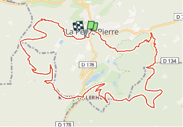
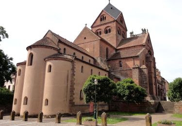
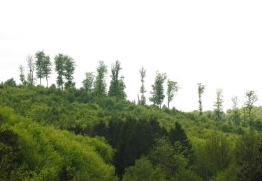
Randonnée Marche de 15,5 km à découvrir à Grand Est, Bas-Rhin, La Petite-Pierre. Cette randonnée est proposée par holtzv.
Description
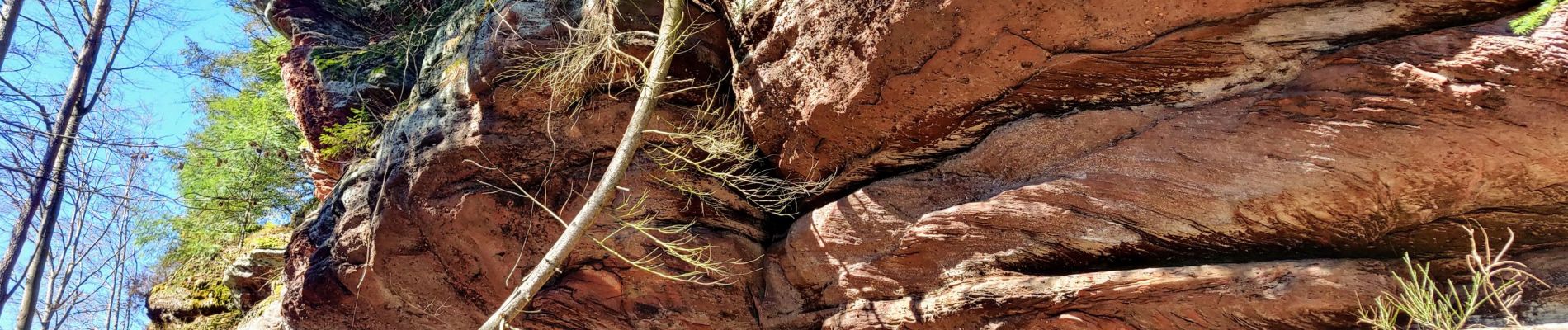
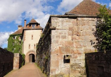
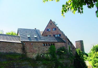
Marche autour de La Petite Pierre en passant par le Hirschfels, le Rocher des Païens, le Rocher Blanc et le château de LPP.
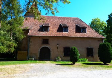
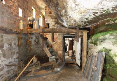
Passage par les maisons troglodytes de Graufthal en rentrant.
Localisation
Pays :
France
Région :
Grand Est
Département/Province :
Bas-Rhin
Commune :
La Petite-Pierre
Localité :
Unknown
Départ:(Dec)
Départ:(UTM)
376664 ; 5412871 (32U) N.
Commentaires
Randonnées à proximité
![Randonnée A pied La Petite-Pierre - Triangle vert - Photo](https://media.geolcdn.com/t/375/260/038b5fbd-ad7d-4d8f-a6b9-4f60e8eebeb8.jpeg&format=jpg&maxdim=2)
![A pied A pied](https://static1.geolcdn.com/sitytour/trail-icons/100.png)
Triangle vert
A pied
Facile
La Petite-Pierre,
Grand Est,
Bas-Rhin,
France
![](/images/other/stat-length.png)
15,1 km | 19,2 km-effort
4h 22min
![](https://static1.geolcdn.com/siteimages/upload/files/16400158638029165_repeat_loop_refresh_sync_direction_icon.png)
Non
![Randonnée A pied La Petite-Pierre - Anneau bleu - Photo](https://media.geolcdn.com/t/375/260/35782fa9-c86a-4f9f-b3fb-0294497c25ab.jpeg&format=jpg&maxdim=2)
![A pied A pied](https://static1.geolcdn.com/sitytour/trail-icons/100.png)
Anneau bleu
A pied
Facile
La Petite-Pierre,
Grand Est,
Bas-Rhin,
France
![](/images/other/stat-length.png)
4,7 km | 6,8 km-effort
1h 33min
![](https://static1.geolcdn.com/siteimages/upload/files/16400158638029165_repeat_loop_refresh_sync_direction_icon.png)
Oui
![Randonnée A pied Eschbourg - Triangle rouge - Photo](https://media.geolcdn.com/t/375/260/57edd1a6-0e36-4f96-89de-82f1bb4d165c.jpeg&format=jpg&maxdim=2)
![A pied A pied](https://static1.geolcdn.com/sitytour/trail-icons/100.png)
Triangle rouge
A pied
Facile
Eschbourg,
Grand Est,
Bas-Rhin,
France
![](/images/other/stat-length.png)
6,8 km | 9,7 km-effort
2h 12min
![](https://static1.geolcdn.com/siteimages/upload/files/16400158638029165_repeat_loop_refresh_sync_direction_icon.png)
Non
![Randonnée A pied Eschbourg - Chemin des Fontaines - Photo](https://media.geolcdn.com/t/375/260/9fa6b123-6a59-4826-87c9-3e3b8ee198f6.jpeg&format=jpg&maxdim=2)
![A pied A pied](https://static1.geolcdn.com/sitytour/trail-icons/100.png)
Chemin des Fontaines
A pied
Facile
Eschbourg,
Grand Est,
Bas-Rhin,
France
![](/images/other/stat-length.png)
6,6 km | 9,1 km-effort
2h 3min
![](https://static1.geolcdn.com/siteimages/upload/files/16400158638029165_repeat_loop_refresh_sync_direction_icon.png)
Non
![Randonnée A pied Dossenheim-sur-Zinsel - Croix rouge - Photo](https://media.geolcdn.com/t/375/260/b7766ade-9612-4826-b6b4-3f8dbf585374.jpeg&format=jpg&maxdim=2)
![A pied A pied](https://static1.geolcdn.com/sitytour/trail-icons/100.png)
Croix rouge
A pied
Facile
Dossenheim-sur-Zinsel,
Grand Est,
Bas-Rhin,
France
![](/images/other/stat-length.png)
13,2 km | 17,1 km-effort
3h 53min
![](https://static1.geolcdn.com/siteimages/upload/files/16400158638029165_repeat_loop_refresh_sync_direction_icon.png)
Non
![Randonnée A pied La Petite-Pierre - Triangle rouge - Photo](https://media.geolcdn.com/t/375/260/ac14cb89-5ba1-4ba9-9b9a-6e7178a855f4.jpeg&format=jpg&maxdim=2)
![A pied A pied](https://static1.geolcdn.com/sitytour/trail-icons/100.png)
Triangle rouge
A pied
Facile
La Petite-Pierre,
Grand Est,
Bas-Rhin,
France
![](/images/other/stat-length.png)
9,6 km | 13,1 km-effort
2h 59min
![](https://static1.geolcdn.com/siteimages/upload/files/16400158638029165_repeat_loop_refresh_sync_direction_icon.png)
Non
![Randonnée A pied La Petite-Pierre - Chevalet bleu - Photo](https://media.geolcdn.com/t/375/260/b7766ade-9612-4826-b6b4-3f8dbf585374.jpeg&format=jpg&maxdim=2)
![A pied A pied](https://static1.geolcdn.com/sitytour/trail-icons/100.png)
Chevalet bleu
A pied
Facile
La Petite-Pierre,
Grand Est,
Bas-Rhin,
France
![](/images/other/stat-length.png)
9,8 km | 13,6 km-effort
3h 5min
![](https://static1.geolcdn.com/siteimages/upload/files/16400158638029165_repeat_loop_refresh_sync_direction_icon.png)
Non
![Randonnée A pied La Petite-Pierre - Rectangle jaune barré de blanc - Photo](https://media.geolcdn.com/t/375/260/e8786cd5-b21f-4723-bb2c-f0f19066f62a.jpeg&format=jpg&maxdim=2)
![A pied A pied](https://static1.geolcdn.com/sitytour/trail-icons/100.png)
Rectangle jaune barré de blanc
A pied
Facile
La Petite-Pierre,
Grand Est,
Bas-Rhin,
France
![](/images/other/stat-length.png)
3,9 km | 5,4 km-effort
1h 13min
![](https://static1.geolcdn.com/siteimages/upload/files/16400158638029165_repeat_loop_refresh_sync_direction_icon.png)
Non
![Randonnée A pied La Petite-Pierre - Triangle bleu - Photo](https://media.geolcdn.com/t/375/260/33b3a588-f228-473c-8257-55ea2d8fff1e.jpeg&format=jpg&maxdim=2)
![A pied A pied](https://static1.geolcdn.com/sitytour/trail-icons/100.png)
Triangle bleu
A pied
Facile
La Petite-Pierre,
Grand Est,
Bas-Rhin,
France
![](/images/other/stat-length.png)
5,8 km | 7,5 km-effort
1h 41min
![](https://static1.geolcdn.com/siteimages/upload/files/16400158638029165_repeat_loop_refresh_sync_direction_icon.png)
Non